Streaming-potential (SP) is an electrical surveying method used when fluids or electrolytes—typically water—move through porous areas in the the ground. This creates a change in voltage that can be read using a voltmeter and two electrodes.
Streaming-potential (SP) is an electrical surveying method used when fluids or electrolytes—typically water—move through porous areas in the the ground. This creates a change in voltage that can be read using a voltmeter and two electrodes.
Before we dive into details, let’s start with a primer on three different terms that are abbreviated “SP.” In this article, we’ll be discussing self-potential, which is synonymous with spontaneous-potential. The self-potential method in geophysics refers to an electrical surveying method used for looking at electrical anomalies in the ground. It is primarily used in mineral exploration. Streaming-potential, on the other hand, is caused by a fluid —typically water with dissolved minerals (an electrolyte)—moving in the ground, which causes a change in voltage. This change is detected when a reading is taken.
One-dimensional (1D) resistivity surveys are not ideal because they assume that the geological layers are horizontal and homogeneous—which is rarely the case. Two-dimensional (2D) resistivity surveys are an improvement but still an approximation, as they assume the geology continues infinitely in both directions perpendicular to the survey line. While this method is more accurate than the 1D Vertical Electrical Sounding (VES) method, it is still inadequate.
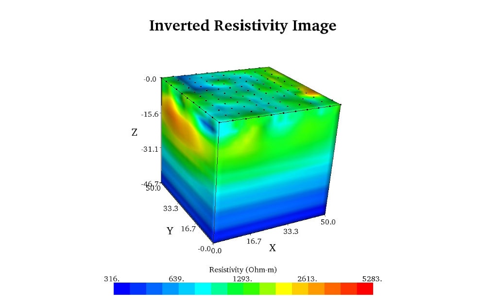
The three-dimensional (3D) time-lapse resistivity survey is the holy grail of resistivity surveys. It is an extremely accurate and effective method that allows you to not only see the surveyed area in three dimensions—but also how the resistivity in the surveyed area changes over time.
Induced polarization (IP) is the Earth’s capacity to hold an electric charge over time. IP measures the voltage decay curve after the injected current is shut off. The higher the IP, the longer over time the charge is held—IP decays over time, typically a few seconds but sometimes up to minutes, and will eventually disappear. IP is especially useful for mineral exploration applications.
Inversion is the mathematical process of calculating cause from a set of observations. In resistivity work, it is used to calculate the resistivity of different formations in the ground from a set of readings taken at the surface or between boreholes.

Have you ever prepared for a vacation, only to arrive at your destination and realize you’d neglected to pack important attire and equipment for your holiday? Recently, in my haste to prepare for a trip, I didn’t make a list and found myself in this very situation—I ended up wearing wool sweaters and jeans in an 80-degree climate.

Dr. Keith N. Muhlestein, PG, REM, from the University of Texas at San Antonio’s Environmental Science and Engineering department, used AGI equipment for an electrical resistivity survey to image Karst regions within Friesenhahn Cave in Texas.

In the 1980s and early 1990s, geophysicists became largely disenchanted with electrical resistivity because of the inadequacies of Vertical Electrical Sounding (VES). Specifically, the VES method assumes that the imaged geology is horizontally layered and that each layer is homogeneous. Of course, this often isn’t the case, causing some project managers (and their clients) to become fed up with the unusable results.
Topics: field training

Throughout most of the 20th century, Vertical Electrical Sounding (VES) was the dominant geophysical resistivity method. It has been used all over the world for three primary purposes: geotechnical investigation, groundwater exploration, and mineral exploration.